Failed to execute CGI : Win32 Error Code = 2
Failed to execute CGI : Win32 Error Code = 2
Contrails Over The Northeastern US - March 12, 2001
Contrails over the Northeastern
US -
March 12, 2001
By Jay Reynolds
4/29/2001
This report reviews a recent story carried by several
sources but begun by Tiffany Brendt and William Thomas which appears
at the website of William Thomas titled
FAA
OFFICIAL CONFIRMS AIR FORCE
TANKERS CONDUCTING WEATHER
MODIFICATION OVER U.S. AND CANADA
William Thomas, one of the most egregious promoters
of "chemtrails", has a long history of exaggeration,
obfuscation, and has made many unsupported and false claims over
the past three years which have caused him to be "disassociated"
by Environment News Service, to
be discredited among many "chemtrail" believers,
and not
even mentioned by mainstream media covering the story.
My report begins by establishing a time line for
the events, describing some of the people involved, and discussing
what is known about normal air traffic in the area in question.
Alleged "chemtrail" photos from the area are presented
and compared to normal contrail photos from the area by a professional
meteorologist. Alleged "chemtrail" planes photographed
from the area are compared to known types of aircraft.
The second part of this report is an actual survey of normal commercial
air traffic over the exact same area, at the same time period
and day of the week using commercially available "Flight
Explorer" software, which allows access to FAA Air Traffic
Control data other than military aircraft.
TIME LINE
Sondra Tiffany Brendt(formerly Luttrell)of Parsonsfield,
Maine, heard about "chemtrails"
from Philip Marie(Jr.&Sr.) of Conway, NH, around two years
ago. On the morning of March 12, 2001, she and a friend, Lou Aubuchont,
observed numerous contrails over their home, which were being
formed at high altitude in a northeast to southwesterly direction.
Between 12 noon and 1 pm, at least 30 trails were observed. Parsonsfield
is about 30 miles WNW of Portland, ME.
According to Brendt, she contacted the air traffic control
tower at the Portland Jetport, where the ATC manager told her
that nine jets had arrived/departed the Jetport. The Portland
tower controls arriving and departing aircraft, but not the high
altitude enroute traffic, which are controlled from the Boston
Center (based in Nashua, NH). The Portland tower Air Traffic Control
manager told Brendt that on their radar they normally filter out
flights over 10,000 ft., because they only control that airspace.
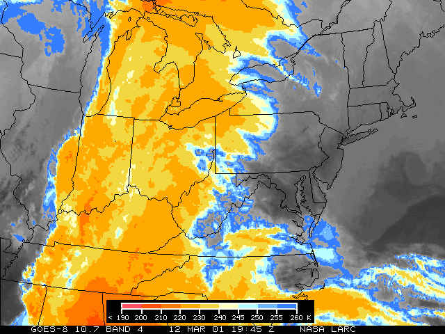
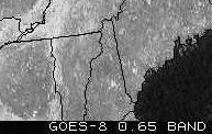
This set of 3 images from the GOES-8
satellite shows the progression of a frontal system which entered
the northeastern US on 3/11/2001, preceded by cirrus cloudiness,
and fully involved the area by 3/13/2001.
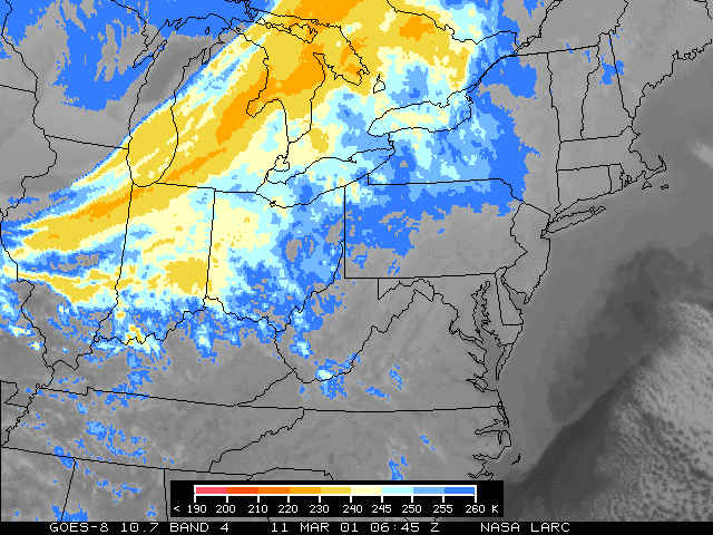 <=March 11, 2001
Ā
<=
March 12, 2001
Ā
Ā
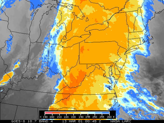
<=March 13,
2001
Ā
Ā
Ā
Ā
Here are two images from the MODIS
imager on the Terra
satellite that
passed over Maine at 11:15 am EDT on March 12, 2001.
The IR picture below shows a few high clouds over Maine, a bright
white
(cold, high cloud) oval area in southern Maine, and a triangular
shaped
cloud in south central Maine. There appear to be a few spreading
contrails
over Vermont and NY. 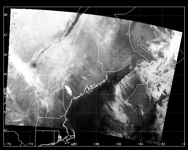 Ā
Ā
 The BTD image above is a brightness temperature difference
method used
The BTD image above is a brightness temperature difference
method used
to help detect contrails. It uses two different infrared wavelengths.
You
can see that the contrails in Vermont and NY are more evident.
That triangular
cloud is probably a spreading contrail. Those stripes over Nova
Scotia are
just wave clouds. The high thin cirrus extending from Canada into
northern NY and
through most of Vermont contains the Vermont contrails and one
or two others
in southern Canada. There may also be one in eastern NH and next
to the oval in
Maine. The large thin cirrus cloud is the one that you see moving
over
Maine in the GOES imagery. Viewers from below would probably see
those
embedded contrails.
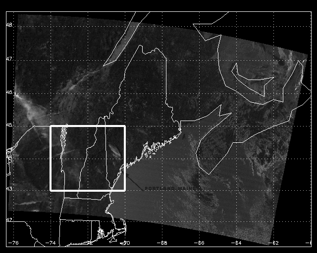
The image below is from the GOES-8 satellite taken
on March 12 at 15:15 UTC(1:15 PM EDT) , and appears to show several
contrails over the Parsonsfield, ME area. Click
here for the uncropped image.
 Ā
Brendt contacted William Thomas on March 16th and
sent this
message.
Ā
According to Brendt, she conducted an interview
with an "Air Traffic Control Manager",
Ā
Brendt contacted William Thomas on March 16th and
sent this
message.
Ā
According to Brendt, she conducted an interview
with an "Air Traffic Control Manager",
who remains anonymous. Her anonymous source said, when asked why
he was told to reroute air traffic, "We had to bring in
a couple in lower." and "I was told that there
was a military exercise in the area."
In another taped segment, Brendt's anonymous source,
when asked "Was radar degraded or enhanced on March 12th?"
replied, "Somewhat degraded, yes." "Yes,
there was what you would call a haze."
When asked, "Was this a weather modification
experiment?", Brendt's anonymous source
said, "That approximates what I was subsequently told."
On April 3rd, William Thomas sent out this news
release.
Within hours of posting Thomas' news release, Rense.com
added this disclaimer:
"(NOTE - We do not necessarily think this story explains
anything more than what it purports: that military operations
of some type were carried out at a certain altitude on several
occasions which allegedly necessitated the re-routing of some
incoming civilian air traffic in the Northeast. There are dozens
of potential military operations which might account for the need
to clear airspace. There are apparent typos and inconsistencies
in the text of this 'news release' such as: "While air traffic
controllers normally ignore air traffic above 10,000 feet, the..."
Certainly, this is an inaccurate statement because air traffic
controllers DO NOT 'normally ignore air traffic above 10,000 feet'.)
On April 4th, William Thomas posted
this message to his website.
On April 4th, Brendt appeared on the radio program
"Sightings",
with host Jeff Rense, but minus William Thomas.
[note:
click on this audio file marked April 4, and use the realaudio
play feature to seek the audio to the interview which begins 59
minutes into the program.]
A
transcript of the audio link above, consisting of an
interview between Jeff Rense and Tiffany Brendt, and excerpts
of the interview with an anonymous person claiming to be an Air
Traffic Control Manager can be found here.
Later on April 4th, Brendt and Thomas appeared on
The Art Bell program together, and played a more lengthy version
of the audiotape interview with the "ATC Manager":
[Click
this link for windows media player audio of the interview, which
begins 30 minutes into the show]
Currently, William Thomas carries this
article on his website, and has presented no confirmable or
documented evidence supporting his and Brendt's claims, and the
alleged "Air Traffic Control Manager" remains anonymous.
William Thomas' typical pattern, which has been repeated time
and time again, is to make claims for which he never presents
documented or verifiable evidence. He has, at various times over
the past two years, claimed the following:
-That
JP-8 jet fuel contains ethylene dibromide
-That
"chemtrails" contain bacteria and molds
-That
"chemtrails"can cause HEPATITIS A, RABIES, and EPSTEIN
BARR VIRUS
In each case above, no evidence has ever been produced,
no "lab reports" as claimed, no medical reports, no
substance or material analysis. After deluging his followers with
these horror stories William Thomas does offer hope, he pitches
vitamins after asking,
"Are
chemtrails getting you down?"
There is a possibility that military weather experiments
have taken place.
At this time, a reasonable person should not place too much faith
in William Thomas' sources, especially one that is anonymous,
based on his past performance.
I have spoken with Tiffany Brendt by telephone, and she sounds
convinced, but did admit that Thomas' report
contains a factual error. He states,
"The FAA official decided to come forward after his wife
was stricken with
what doctors diagnosed as Sudden Adult Onset Asthma following
the March
12 aerial onslaught. She has no history of allergy. Their children
also suffered
asthmatic reactions, including an infant son who was rushed to
hospital with a
gushing nose bleed."
During a telephone call with
Tiffany Brendt on April 29th, 2001, Brendt told me the alleged
illness predated her sightings of March 12th.
Review of Normal Air Traffic
Patterns in the Area
Ā
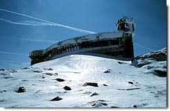 Contrail photograph taken by Dave Thurlow at Mount
Washington Observatory, Conway, New Hampshire, the same town where
WMWV Asst. News Director Richard Dean reported observing 370 "chemtrails"
on March 12th.
Contrail photograph taken by Dave Thurlow at Mount
Washington Observatory, Conway, New Hampshire, the same town where
WMWV Asst. News Director Richard Dean reported observing 370 "chemtrails"
on March 12th.
Ā
Meteorologist Dave Thurlow of the
Mt. Washington Observatory
says
this about "chemtrails":
"I think it's a joke, I
mean really at first I thought it was some kind of parody of doomsayers.
But now, I think they mean it."
(click
here for a real audio interview with Dave Thurlow)
On April 17th, 2001, Susan Ross-Parent, Director
of Listener Services at the Mount
Washington Observatory, asked to comment on the Brendt/Thomas
report stated:
"Right now we're going to stand with our broadcast (see
link above)."
In the Rense interview transcript,
Brendt makes this statement:
" No, not where we are,
weÆre not under a major flight path."
During a telephone call with
Tiffany Brendt on April 29th, 2001, she admitted to me that she
had never seen an aeronautical chart of her area.
Ā
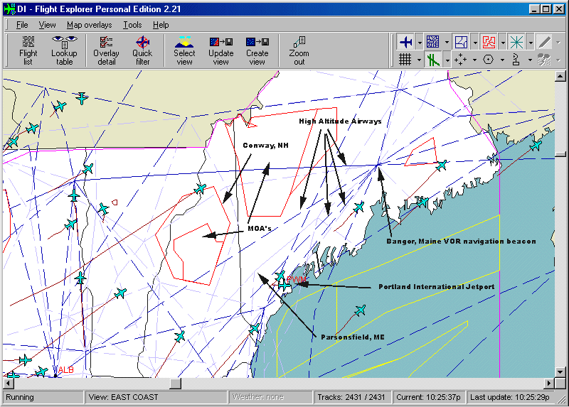 The above Flight
Explorer display of Maine and New Hampshire
The above Flight
Explorer display of Maine and New Hampshire
shows Airways and Special Use Areas(Yellow)
Ā
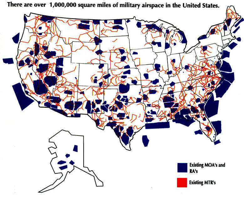 Note that a large Military Operations Area is known
to exist in western Maine, another in northern New Hampshire,
and two special use areas off the coast of Maine.
Note that a large Military Operations Area is known
to exist in western Maine, another in northern New Hampshire,
and two special use areas off the coast of Maine.
Here are the FAA
regulations for use of these areas.
Here is a USAF fact
sheet on the subject.
Ā
Ā
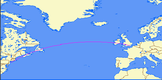 Map shows typical "Great
Circle" routing for transatlantic flights.
Map shows typical "Great
Circle" routing for transatlantic flights.
The North Atlantic Corridor is the most heavily
traveled air
corridor in the world, with over 600 flights/day to and from Europe
 and North America. To facilitate organized
Atlantic crossing,
and North America. To facilitate organized
Atlantic crossing,
the International Civil Aviation Organization(ICAO) has
established a North
Atlantic Track(NAT) system of organized
flight corridors, which are changed each day to avoid storms and
jet stream winds. Due to these changing courses, planes may
deviate significantly in their point of arrival/departure over
US airspace from day to day.
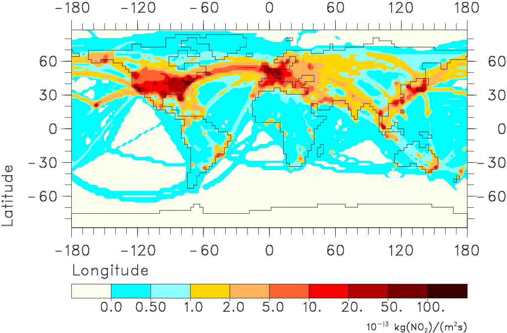
The image below shows worldwide emissions from aircraft of NOx
, a pollutant formed by all types of hydrocarbon combustion when
nitrogen is combined with oxygen. The POLINAT
study image #1 shows this pollution. Vertically integrated NOx
emissions from aircraft including military according to the DLR2
data set (see Schmitt et al., DLR-Mitt. 97-04). Global emissions:
0.56 Tg(N) yr-1.
 Review of Photographic Evidence
of Alleged "Chemtrails" in the Area.
Ā
Review of Photographic Evidence
of Alleged "Chemtrails" in the Area.
Ā
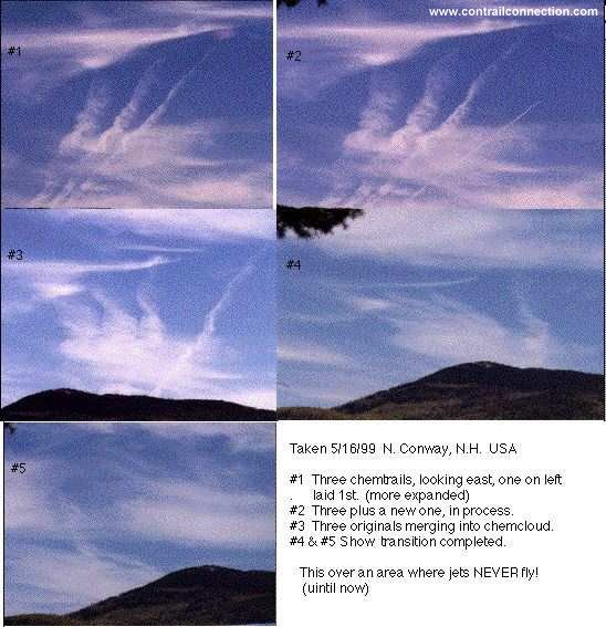 The above image, from contrailconnection.com
was made by Philip I. Marie, Sr. of Conway, New Hampshire, location
of WMWV radio where Brendt works. According to Brendt, Marie and
his son introduced her to the "chemtrails" idea. Marie
states:
"This is over an area
where jets NEVER fly!(until now)"
The above image, from contrailconnection.com
was made by Philip I. Marie, Sr. of Conway, New Hampshire, location
of WMWV radio where Brendt works. According to Brendt, Marie and
his son introduced her to the "chemtrails" idea. Marie
states:
"This is over an area
where jets NEVER fly!(until now)"
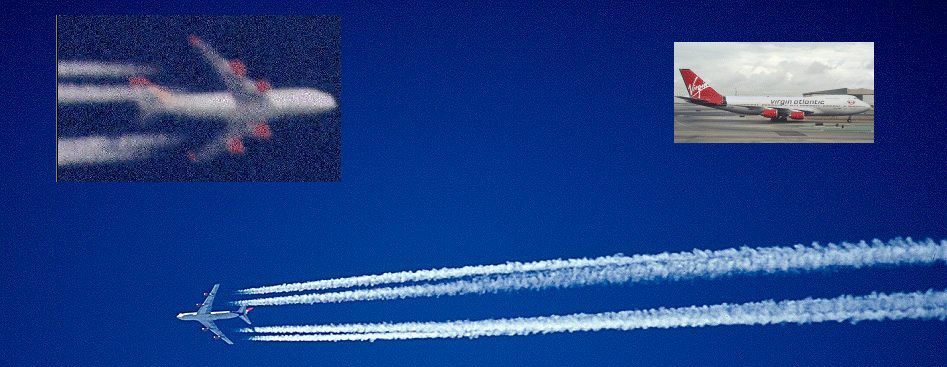 The background image above, showing normal contrails,
is from airliners.com of a well-known Virgin
Atlantic Airlines 747 (cn-22791) "G-VIBE". The left
inset image was taken by Philip Marie over Conway, NH, in 1999,
who says, "it
was a chemplane as nothing else ever flies over central NH",
however, the shape and paint scheme match typical Virgin Atlantic
livery colors of red engines and tail as shown in the right inset
image. The Flight Explorer study which follows shows this airline
operates flights over the area, and one is shown passing over
the Parsonsfield area on Monday, April 16th.
Calculating the distance at which
a contrail could be seen
The background image above, showing normal contrails,
is from airliners.com of a well-known Virgin
Atlantic Airlines 747 (cn-22791) "G-VIBE". The left
inset image was taken by Philip Marie over Conway, NH, in 1999,
who says, "it
was a chemplane as nothing else ever flies over central NH",
however, the shape and paint scheme match typical Virgin Atlantic
livery colors of red engines and tail as shown in the right inset
image. The Flight Explorer study which follows shows this airline
operates flights over the area, and one is shown passing over
the Parsonsfield area on Monday, April 16th.
Calculating the distance at which
a contrail could be seen
 For all practical purposes,
the distance that a contrail from an airplane flying 30,000 ft
can be viewed is the maximum visibility allowed by atmospheric
conditions. For example, the formula which can be used to calculate
the actual distance D, as shown in the image at left, is:
For all practical purposes,
the distance that a contrail from an airplane flying 30,000 ft
can be viewed is the maximum visibility allowed by atmospheric
conditions. For example, the formula which can be used to calculate
the actual distance D, as shown in the image at left, is:
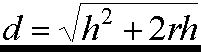
where:


A = the contrail


h = altitude of the contrail ~6 miles(31,200ft)


r = 4000 miles(radius of the earth)


then d = (the square root of) (6X6)+ 2(4000)(6)


d= distance that a contrail would be visible


d=219 miles


It is thus shown that such a contrail would easily be visible

for at least 50 miles, depending on the visibility and the height

of the observer above the ground.
These calculations are the same as

sailors use to find the distance to the horizon. William Thomas,

who claims to be an experienced sailor, certainly knows this basis

for terrestrial navigation.
Ā
Continue on to Flight Explorer Study of Air Traffic

Over Parsonsfield, Maine on a Monday Between 12


Noon and 1 PM
Back to Contrails- or Trails-Con?

 Note that a large Military Operations Area is known
to exist in western Maine, another in northern New Hampshire,
and two special use areas off the coast of Maine.
Note that a large Military Operations Area is known
to exist in western Maine, another in northern New Hampshire,
and two special use areas off the coast of Maine.